
Route 719 South Area Plan
I. PURPOSE AND SCOPE OF PLAN AMENDMENT
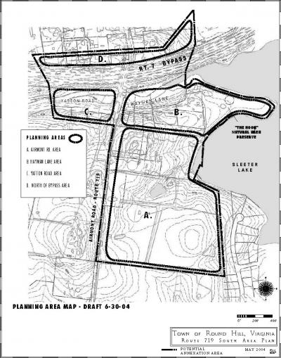
This plan document amends the Town of Round Hill Comprehensive Plan, as adopted by the Round Hill Town Council on November 18, 1993, to add a new planning area, hereafter called the Route 719 South Planning Area. The Route 719 South Planning Area, is newly incorporated into the Town’s corporate limits.
For the purposes of this planning document, any references to “Round Hill” or “the Town” shall be taken to mean the current corporate limits of the Town of Round Hill, prior to the annexation of the Route 719 South Planning Area.
II. GOALS
This plan reaffirms the primary goals of the Town of Round Hill Comprehensive Plan, as adopted by the Round Hill Town Council on November 18, 1993, and the Loudoun County Round Hill Area Management Plan (hereafter referred to as RHAMP), as adopted by the Loudoun County Board of Supervisors on January 2, 1990, while it specifically seeks to achieve the following goals within the new planning area:
- Ensure safe and calm auto, pedestrian and bicycle traffic along Route 719 while maintaining its rural and scenic visual character.
- Provide a safe, efficient, accessible circulation network which accommodates vehicular, pedestrian and biking modes of transportation in the planning area and which provides adequate transportation linkages to the region.
- Conserve and protect the natural, historical and archaeological endowments of the planning area while promoting the provision of appropriate public facilities, utilities and services in a manner which causes the least environmental, social or community discord.
- Preserve the rural residential character of the planning area and recognize single family residential as the planned land use for the area.
- Emphasize neighborhood focus and establish efficient land use patterns in new development. Develop environmentally sensitive land use patterns in both small and large-scale developments.
- Ensure that new developments are compatible with the Town’s natural, historic and architectural resources for present and future residents.
- Preserve open space and ensure that land development is accomplished in a manner which reduces pollution and conserves energy resources as well as prevents significant adverse alteration or damage to regional and local ecological systems on a macro and micro scale.
- Provide a range of housing opportunities with a diversity of sizes, types and cost ranges that reflect the variety of single family neighborhoods in the existing developed portions of Round Hill.
- Manage the level and timing of development in the planning area in order to ensure fiscally balanced growth which will not unduly strain County or Town resources including County and Town budgets, the natural environment, the transportation network, public facilities and utilities.
- Coordinate planning efforts between the Town and County in the provision of public utilities and facilities to manage the timing of development, prevent undesirable environmental and fiscal impacts and maintain a mutually supportive relationship between jurisdictions.
- Preserve the quality and character of the existing rural environment of the area, including views from Route 719 as the southern “gateway” into Round Hill.
III. GENERAL PLANNING AREA POLICIES
A. GENERAL POLICIES
The potential for new residential growth within the corporate limits of the Town of Round Hill is severely limited by a lack of vacant land within the Town. Therefore, the Town will encourage a limited amount of new residential development to take place around the existing Town within the designated planning area established in this Plan Amendment. Any new residential development, however, will undoubtedly affect the relationship of the existing Town of Round Hill relative to its pastoral surroundings. In order to minimize this impact, new development shall occur as a natural and compatible expansion of the existing Town. In every case, new development shall exhibit a character and quality which is compatible with the existing Town and which reflects the traditional historic settlement pattern and urban design features of Loudoun County settlements.
- This Plan Amendment specifically adopts the policies that are in Loudoun County’s Round Hill Area Management Plan, as adopted January 2, 1990 and amended, for the planning area. Where there is conflict between the policies in this Town Plan amendment and the policies in the Round Hill Area Management Plan or the Town Comprehensive Plan, the policies in this Town Plan Amendment shall govern.
- The Town shall promote single family residential as the planned land use in the annexed area.
- New development along Airmont Road (Route 719) shall effect an appropriate transition from the surrounding rural countryside character to the historical Town character. This area is an important “gateway” to the Town and shall serve to visually reinforce entry into Round Hill, to calm and manage vehicular traffic entering Town in a safe and efficient manner, and to reinforce the Town’s streetscape and development pattern.
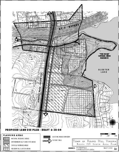
- In order to protect the rural character of Route 719, as well as environmentally sensitive lands in the planning area, new residential development shall be clustered in areas designated on the Land Use Plan for residential development, and shall be excluded, or developed at very low densities, in areas that are designated as environmentally sensitive, as shown on the Land Use Plan.
- New development in the planning area shall exhibit a character and quality which is compatible with the existing Town. Although the planned residential density in this planning area is generally lower than the existing residential density in the Town, the form and character of the new development shall match the traditional settlement pattern and urban design features of Round Hill.
- The Town will consider rezonings for higher residential density in the planning area, up to a maximum density of one unit per acre, based upon a finding that the proposed rezoning(s) satisfy the following development standards:
- The proposed development exhibits a character and quality which is compatible with the historic character of the Town.
- The proposed development does not increase the Town’s or County’s financial burden to pay for public facilities and services, or decrease the quantity or quality of those public facilities and services.
- Clustering of residences on suitably designated land within the planning area served by central sewer and water shall be encouraged as a method to obtain additional open land. In no case shall the average density of the resulting development be greater than it would have been without clustering unless rezoning is also involved. Permanent open space easements shall be placed on the residual open space land which will preclude further development.
- In areas designated as suitable for clustered residential development on the Land Use Plan, the lot areas may be smaller than one acre; however, maximum densities within any individual property in the planning area shall be no greater than one unit per acre.
- For the purposes of density calculations, net acreage shall be used, excluding lands in floodplain, lands with steep slopes of 25% or over, and lands to be devoted to non-residential development.
- The Town shall formulate a Town-wide policy and plan to address the need for affordable housing within the Town.
- For the purposes of providing affordable housing only, attached housing types, such as duplexes, may be considered by the Town in a rezoning application, provided that the density on any individual tract does not exceed one unit per acre.
- The Town does not support the creation of Homeowner’s Associations for new development in the Route 719 South Planning Area, except for limited management associations solely for the purpose of maintaining private roads or parks within new neighborhoods.
- The Town may initiate a comprehensive re-mapping of the area located along Hayman Lane and Yatton Road to promote affordable housing opportunities and in recognition that the existing pattern of small lots is incompatible with the large lot zoning of the area posing many non-conformity issues for current property-owners .
B. RESOURCE DISTRICTS
The following specific Resource Districts are shown on the accompanying Land Use Plan and are established in order to:
- Protect environmentally sensitive and scenic areas
- Limit development to areas where it is least disruptive to the environment and to public views
- Further the overall goals and policies of this Plan Amendment and the Town’s Comprehensive Plan.
NATURAL RESOURCE PROTECTION AREAS
These areas, as shown on the Land Use Plan, are restricted from development by 100-year floodplain, in addition to the Town’s natural area preserve on the “Hook.” These areas shall remain undeveloped and every effort shall be made to maintain or restore them to their natural state as sheltered wildlife habitat and indigenous vegetation.
Some limited passive recreation may occur in these areas, such as hiking and nature study, provided any improvements are designed in an environmentally sensitive manner that maintains the ecological health of the surrounding land.
ENVIRONMENTALLY SENSITIVE AREAS
These areas, as shown on the Land Use Plan, are environmentally sensitive or otherwise desirable to be preserved because of their natural resource value, such as areas of steep slopes (15%-25% and above) and/or significant woodlands.
These areas shall be preserved as open space or developed as very low density rural-type development, such as large estate lots with minimum individual lot sizes of three acres.
Any development in these areas shall be of a very environmentally sensitive nature and construction shall avoid altering areas of woodland or steep slopes to the greatest extent possible. Disturbed areas shall be stabilized and replanted with dense native vegetation.
CRITICAL VIEWSHED AREAS
These areas, as shown on the Land Use Plan, are visible from Airmont Road (Route 719) and are of vital scenic importance in establishing and maintaining the overall scenic character of the southern gateway and approach to Round Hill.
In general, these areas shall either be maintained in a rural, open character, or be developed with a pattern of residential development that is compatible with the Town’s traditional historic development pattern, including the following design features:
- Houses aligned so that their front facades face onto Airmont Road, with vehicular access from the side or the back, and no driveway access onto Airmont Road.
- Lots of approximately ½ acre in size, with length-to-width proportions and street orientation that is consistent with the existing historical pattern of the Town, especially as it exists along Loudoun Street, Main Street and New Cut Road.
- Houses that exhibit an architectural massing, form and character that is consistent with the town’s historic architectural fabric, including detached garages and outbuildings that complement the main house architectural style.
RESIDENTIAL CLUSTER AREAS
These areas, as shown on the Land Use Plan, are either already developed with existing homes, or are suitable for new residential development. They are generally suitable for single family detached housing, which can be clustered with lot sizes as small as ¼ acre, if served by public water and sewer.
- Although clustered development with lot sizes as small as ¼ acre is encouraged, the density of any individual property in the annexed area shall not exceed one unit per acre.
- Cluster development is encouraged in these areas, in order to limit development in the other Resource Districts, listed above, in which development is more restricted.
- The residential development shall exhibit a character and quality which is compatible with the existing Town and which reflects the traditional settlement pattern and urban design features of Round Hill and other historic Loudoun County settlements.
- The provision of small “pocket parks” and other small civic spaces and formal open space is encouraged, within the residential subdivisions, as a focus for community activity and visual amenity.
IV. POLICIES FOR SPECIFIC PLANNING AREAS
AIRMONT ROAD AREA
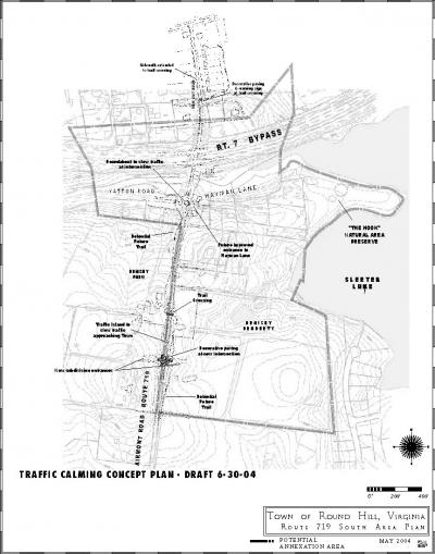
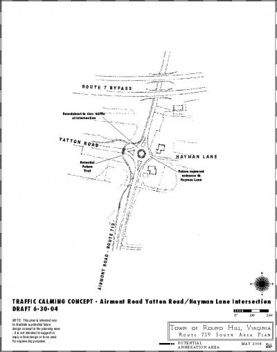
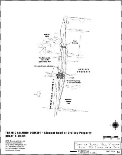
The Town shall seek to develop traffic calming measures on Airmont Road throughout the Route 719 South Planning Area, in order to protect the safety of vehicles and pedestrians in the historic portion of the Town. Specific traffic calming measures may be signalization, roundabouts, “speed tables” or other mechanisms to effectively slow traffic approaching Town in a safe and functionally appropriate way. A potential design for traffic calming improvements is shown on the attached Traffic Calming Concept Plan. However, the detailed location and type of traffic calming should be determined based on a study undertaken for that purpose. The Town should seek assistance from VDOT and/or the development community in constructing the traffic calming improvements.
Airmont Road shall retain its rural historic character as the southern gateway to Round Hill. A paved hiker/biker trail shall be developed along Airmont Road, as generally shown on the Proposed Land Use Plan. The trail shall conveniently connect new and existing residences to the Town and to surrounding areas. Safety, accessibility and comfort shall be primary considerations in trail design and location. The trail may be on either the east or west side of the road, depending on feasibility but road crossings shall be minimized, and shall be accompanied by highly visible crosswalks, signage and other safety features.
An additional trail shall be provided that connects the trail along Airmont Road with the lake, as generally shown on the Land Use Plan, in order to provide access to passive recreational opportunities in this portion of the planning area.
HAYMAN LANE AREA
The Hayman Lane area is an older established residential enclave with a stable character and shall retain its character and setting. Limited new infill housing may be allowed in this area, up to an overall density of one unit per acre. Some flexibility in lot size and housing type, including attached housing, may be provided in this area, provided that this is primarily done in order to provide affordable housing that is consistent with the scale and character of the Town. The floodplain and steep slope areas shall be protected from development and maintained or restored to a natural state. The Town should pursue a long-range strategy for improving Hayman Lane and bringing it up to current road standards for public use, including access to “The Hook” natural area. The improvements should not cause significant disruption to the existing houses or the natural features in the area. “The Hook” natural area shall remain free of vehicular travelways and shall have pedestrian trails only. Public access to the natural area shall be from Hayman Lane.
YATTON ROAD AREA
This area is primarily undevelopable floodplain, north of Yatton Road, with some developable platted land south of Yatton Road. The character of new development in this area shall be single family detached, shall not exceed one unit per acre, and shall generally match the character of housing in the Town.
A paved hiker/biker trail shall be developed between the existing stream and Yatton Road, to connect with the trail on Airmont Road. The trail shall be designed in an environmentally sensitive way, to minimize disruption to the natural streamside ecology of the site.
NORTH OF BYPASS AREA
This area is functionally an extension of the existing Town development pattern. New development in this area shall be single family detached residential and shall generally match the scale, character and density of the adjacent Town area, and shall preserve steep slopes, significant woods and other environmentally sensitive areas on the site.